Adding the geographical peaks to Google Earth

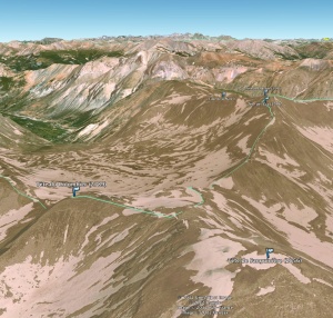
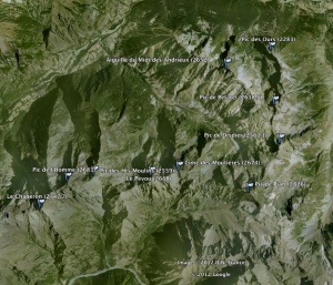
My current version of Google earth doesn’t show any peak. I describe below how I imported them from OpenStreetMap. Here is the end result:

google-earth-osm-peaks

google-earth-osm-peaks-2

  • Download an OSM file for the region you are interested in, for instance from geofabrik. I will use “provence-alpes-cote-d-azur.osm.bz2” here
  • Decompress it:
    bzip2 -d provence-alpes-cote-d-azur.osm.bz2
  • Extract the peaks with Osmosis:
    osmosis -q --rx provence-alpes-cote-d-azur.osm --tf accept-nodes natural=peak --tf reject-ways --tf reject-relations --wx provence-alpes-cote-d-azur-peaks.osm
  • Convert it to KML, removing the timestamps:
    gpsbabel -i osm -f provence-alpes-cote-d-azur-peaks.osm  -x transform,wpt=trk -o kml -F - | grep -vi 'timestamp.*when' > provence-alpes-cote-d-azur-peaks.kml

Finally, open the KML file in Google Earth.

Update 2012-12-04 : you can also modify the OSM file to include the elevation in the names, for a better overview in Google Earth. For that, you will need an XML processor. I use xsltproc here, from libxslt.

<?xml version="1.0"?>

<xsl:stylesheet  xmlns:xsl="http://www.w3.org/1999/XSL/Transform" version="1.0">       
  <xsl:output indent="yes" method="xml"/>
  
  <xsl:template match="/">
    <xsl:apply-templates />
  </xsl:template>
 
  <xsl:template match="@*|*|processing-instruction()|comment()">
    <xsl:copy>
      <xsl:apply-templates select="@*|node()"/>
    </xsl:copy>
  </xsl:template>

  <xsl:template match="tag[@k='name']">
    <xsl:element name="tag">
      <xsl:attribute name="k">name</xsl:attribute>
      <xsl:attribute name="v">
        <xsl:value-of select="@v"/>
        <xsl:text> (</xsl:text>
        <xsl:value-of select="../tag[@k='ele']/@v"/>
        <xsl:text>)</xsl:text>
      </xsl:attribute>
    </xsl:element>
  </xsl:template>
</xsl:stylesheet>

Before you call gpsbabel, use this XSLT sheet to process the OSM file:

xsltproc peaks.xslt provence-alpes-cote-d-azur-peaks.osm   > provence-alpes-cote-d-azur-peaks-processed.osm

It’s of course possible to optimize this process. If you do, it would be nice to post your improvements here.
Personal review of the Garmin Oregon 300

After some time using the Etrex Vista Hcx, I have switched some weeks ago to the Oregon 300.

Here are the pros and cons, including the ones in comparison with the Etrex Vista Hcx.

Pros (common to the Vista Hcx) :

  • Fast boot and GPS fix (typically 15 sec – 1 min )
  • Good dimensions for a hand held device
  • Can be used for turn-by-turn navigation (ie. car) if you have the right map
  • Uses normal AA batteries
  • USB connection and USB mass storage mode (to send the maps or get the logs)
  • Power over USB : very useful in the car, but no battery charging over USB
  • Good battery performance (8h or more)
  • Can save logs (ie. tracks) to the memory card
  • Customizable, ie. :
    • on all pages (map, stats, …) the displayed fields can be defined very precisely (ie. average speed, max speed, ETA…)

Pros compared to the Vista Hcx :

  • Thanks to the touch screen, the controls are much intuitive. Menu structure is very clean (but also require more steps to use, see cons)
  • Scrolling the map is faster and more intuitive
  • It’s possible to have several map files on the card, eg. if you need temporarily a new piece of map, just add the corresponding file to the memory card (no need to regenerate a huge single file). When you don’t need it anymore, just delete it
  • Clips directly on the bike mount. No need for a little piece of plastic and metal like on the Vista Hcx.
  • Different profiles possible, eg. bike, car, walk… (not tested yet)
  • Better screen resolution
  • Openstreemap maps look great (see here the instructions)

Cons (common to the Vista Hcx) :

  • Detailed maps are very expensive, especially for France
  • Batteries can not be charged over USB
  • The altitude displayed and recorded in the tracks is unusable in (pressurized) airplane cabin. The device relies much too much on the barometric altitude. Even the auto-calibration doesn’t help. The algorithm must be changed so that the GPS altitude is taken over when there is a reasonable fix and the different with the barometric altitude is more than eg. 100m
  • Garmin tools do not support MacOS X
  • For the frequency of track points stores in the log, there are 5 settings, but even “Most often” is quite coarse, so I have to force it to “Every second”, but then the track becomes huge very fast. There is no good compromise.
  • Does not record Hdop, Ldop or similar information in the track logs
  • Very limited memory for the current track log, even if you have a big SD card
  • The device has to be held 100% horizontally for the compass to be accurate. If you hold it naturally, ie. at the level of your breast with the screen perpendicular to your visual sight, then you hold it with a 10°+ angle, and that’s enough to get an error of 20° or more in the compass function
  • You can’t decide (and at the beginning it’s not clear) which altitude is displayed or stored in the log (the device can have up to 3 sources : GPS altitude, barometric altitude, map)
  • I really miss a function that would reset the statistics after X hours of inactivity, or ask at startup to do so

Cons compared to the Vista Hcx :

  • The screen is not as bright. Actually, even with the full brightness, it’s not bright enough. On a sunny day, you will have to find/make some shadow to see well
  • The Vista Hcx can save GPX files automatically to the memory card, one per day. The Oregon 300 doesn’t have this feature. A big loss !
  • The Oregon displays the time of day only with hours and minutes, not the seconds. So you used to sync the time of a digital camera by taking a picture of the Garmin’s screen (e.g. for geotagging, openstreetmap), that won’t work anymore.
  • The Vista Hcx has a key to access the settings of the current mode (eg. map, compass…). With the Oregon 300, you have to go back to the root page, and navigate to Settings, and choose the right category, change what you need, and go back to the root page, and return to the mode you were in. Very inefficient !

Other links :

Personal review of the Garmin eTrex Vista Hcx

After several months using my first GPS hand held device, the Garmin eTrex Vista Hcx, here are the pros and cons.

Pros:

  • Fast boot and GPS fix (typically 15 sec – 1 min )
  • Nice and readable screen
  • Good dimensions for a hand held device
  • Can be used for turn-by-turn navigation (ie. car) if you have the right map
  • Uses normal AA batteries
  • USB connection and USB mass storage mode (to send the maps or get the logs)
  • Power over USB : very useful in the car, but no battery charging over USB
  • Good battery performance (8h or more)
  • Can save logs (ie. tracks) to the memory card
  • Customizable, ie. :
    • the main pages (displayed in a round-robin manner, ie. map, compass…) can be switched off or on at wish
    • on all pages (map, stats, …) the displayed fields can be defined very precisely (ie. average speed, max speed, ETA…)

Cons:

  • The controls needs getting used to
  • There is only one main page for the statistics. I miss one more, because I don’t need the same fields in your car as on my bike, so I have to change the fields manually when changing activity
  • Screen resolution could be better
  • Detailed maps are very expensive, especially for France
  • Detailed maps are slow to navigate in when zoomed out
  • Batteries can not be charged over USB
  • The map is one big file at a hard coded location. So there is no way to have 2 map files and choose which one to use on the field (for instance, Garmin maps vs. OpenStreetMap)
  • The map file takes a looooooog time to generate.
  • The map file must be completely regenerated if you want to add a piece of map
  • No MacOS X support for the map file
  • Limited to 2GB cards
  • For the frequency of track points stores in the log, there are 5 settings, but even “Most often” is quite coarse, so I have to force it to “Every second”, but then the track becomes huge very fast. There is no good compromise.
  • Does not record Hdop, Ldop or similar informatio in the track logs
  • The device has to be held 100% horizontally for the compass to be accurate. If you hold it naturally, ie. at the level of your breast with the screen perpendicular to your visual sight, then you hold it with a 10°+ angle, and that’s enough to get an error of 20° or more in the compass function
  • You can’t decide (and at the beginning it’s not clear) which altitude is displayed or stored in the log (the device can have up to 3 sources : GPS altitude, barometric altitude, map)
  • I really miss a function that would reset the statistics after X hours of inactivity, or ask at startup to do so.
  • When the bike clip is fixed, the device doesn’t fit in its case anymore
  • Therefore, you have to remove the clip when not using the device on the bike, but the little thing is easy to loose, and couldn’t even find it to buy on Garmin’s page 😦